Liu Zongyi Interviewed by South China Morning Post
Liu Zongyi source:South China Morning Post
The catastrophic flash floods and mudslide that devastated the Gyirong Port crossing along the China-Nepal border on Wednesday have dealt a heavy blow to China-Nepal trade and imperilled Kathmandu’s push to cut reliance on Indian transit routes.
However, if Beijing and Kathmandu are to proceed with ambitious infrastructure projects, they are expected to take environmental factors into consideration and adjust their construction methods accordingly, one expert said.
Timeline of the China-Nepal border disaster
Chinese officials confirmed three deaths and said more than 500 people, including 260 foreign nationals, remained missing on Thursday. Nepal said more than 900 people were missing, including 517 foreigners, and at 5pm Thursday its official death toll was 359.
China’s Ministry of Natural Resources said on Thursday that the deadly mudslide was initially triggered by a high-altitude glacier collapse inside Nepal that rapidly evolved into a high-velocity debris flow.
According to Guo Zhaocheng, a senior engineer at the Aero Geophysical Survey and Remote Sensing Centre under the ministry, the collapsing ice rushed down the channel at high speed, swept up vast glacial moraine, or scraped rock, and evolved into a debris flow before hitting Gyirong Port and surging downstream into Nepali territory.
Gyirong Port serves as the strategic anchor connecting China and Nepal, handling nearly 30 per cent of total trade volume between the two in 2024, and is a primary overland entry point for Indian pilgrims travelling to Tibet. Some 280 Indian pilgrims remain missing after the disaster, according to India’s Ministry of External Affairs.
Gyirong is one of three international gateways along the 1,415km (879-mile) Himalayan frontier between Nepal and China, where it operates alongside Purang and Zhangmu to handle both passenger travel and cross-border commerce. All six major overland crossings on this border lie within China’s Tibet autonomous region, with the other three functioning exclusively as commercial trade points.
“This massive mudslide has severely affected Gyirong port and will inevitably hit trade between China and Nepal hard,” said Liu Zongyi, director of the Centre for South Asian Studies at the Shanghai Institutes for International Studies.
“Nepal imports far more from China than it exports, so its dependence on the Chinese economy remains significant.
“Establishing road and rail links with China is essential for Nepal if it wants to alter its economic trajectory and geopolitical landscape,” Liu said, highlighting the broader stakes for Kathmandu.
“To transform itself from a landlocked country into a land-linked one, connectivity with China is indispensable.
At the centrepiece of these infrastructure ambitions is the proposed China-Nepal railway, which is currently undergoing feasibility studies. Designed to extend from Shigatse through Gyirong directly to Kathmandu, the megaproject aims to drastically reduce transit times and freight costs across the Himalayas.
Yet the physical realities of the terrain present formidable obstacles.
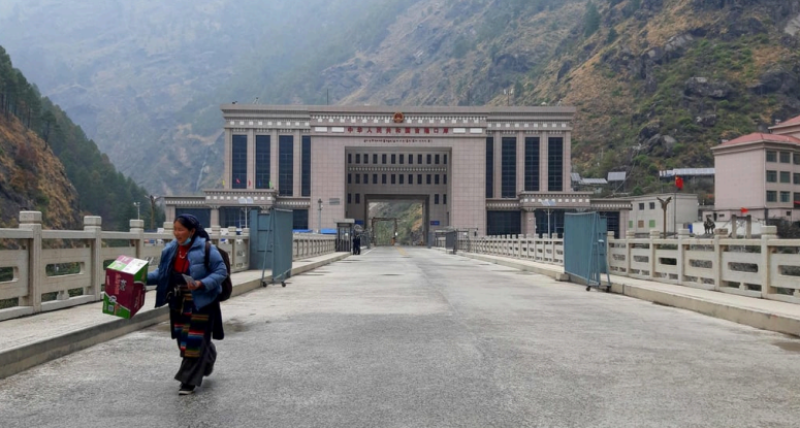
The Gyirong Port Building in the Tibet autonomous region and The Friendship Bridge on the Nepal China Border at Rasuwa is pictured in 2023. Photo: AFP
Liu cautioned that the rail link remained a long-term plan. “The geological conditions along the route are extremely difficult. If the railway is built, it would have to rely heavily on tunnels.”
“These projects are strategic and especially significant for Nepal, as they are crucial for reducing its dependence on India. If construction proceeds in the future, environmental factors will be taken into account and construction methods adjusted to make them more scientific and more rational,” Liu said.
In a push to boost trade with China, the Nepalese government has pledged to start construction on the Tokha-Chhahare Tunnel.
Connecting Tokha in Kathmandu to Chhahare in Nuwakot, the project lies along the vital Kathmandu-Rasuwagadhi transit corridor and could cut bilateral transport costs by up to 50 per cent, according to local media.
China mobilises rescue teams to Nepal border crossing after landslide disaster
Expanding cooperation beyond transit, the two countries are also working to construct a 16km, 220kV power transmission line connecting Nepal’s Chilime region to Gyirong. The landmark initiative is designed to enable two-way electricity trading and optimise seasonal grid balance.
China’s deepening footprint along the Himalayan crest continues to draw scrutiny from India – Nepal’s largest trading partner by a wide margin – which strongly opposes the railway initiative.
New Delhi’s fears that a modern rail and road link stretching from Tibet to Kathmandu brings Chinese logistics closer to the Siliguri Corridor – the narrow, strategic strip of land connecting mainland India to its northeastern states.
By using landlocked Nepal’s economic reliance on Indian transit routes, New Delhi has historically deployed formal and informal restrictions to maintain geopolitical leverage.
Providing Nepal with an alternative overland trade route through China threatens to undermine India’s historical transit monopoly and diplomatic clout over Kathmandu.
The disaster follows a recurring pattern of environmental shocks along the fragile corridor.
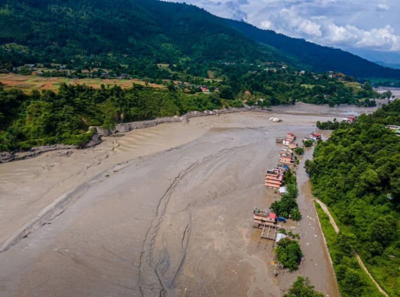
An aerial view shows flooding along the Bhotekoshi River affecting low-lying areas and settlements near the riverbanks. Photo: JNA via ZUMA Press Wire/dpa
In July last year, a glacial lake outburst about 35km upstream in Tibet sent a wall of water surging down the Bhotekoshi River, destroying the Nepal-China Friendship Bridge at Gyirong, halting border traffic for months and leading to 17 deaths.
Researchers from the International Centre for Integrated Mountain Development (ICIMOD), alongside partner organisations in Nepal and China, are assessing whether a high-altitude ice-rock avalanche was the initial trigger for the disaster.
“The Lhende Khola has flooded twice in 14 months, this time most probably triggered by an ice avalanche [that] blocked the river and released a sudden surge downstream,” Saswata Sanyal, a disaster risk reduction specialist for ICIMOD, said in a statement.
According to the US Geological Survey and preliminary assessments by earth scientists, the disaster could have been triggered when a collapsing glacier set off a violent chain reaction that caused a powerful surge of water and debris down narrow mountain gorges into the valley.
Survivors share harrowing accounts of Nepal-China flash floods
Meanwhile, earth scientists are issuing cautions about climate-driven destabilisation of the high Himalayas.
The United Nations reported that Nepal has lost nearly a third of its ice cover in just over 30 years, with glacial loss accelerating 65 per cent faster over the past 10 years than the previous decade.
Rising temperatures are actively thawing the region’s permafrost – the centuries-old frozen soil and rock anchoring the steep mountain faces. As the structural binder thaws, massive rock and ice formations will become unstable, turning routine slope failures into catastrophic torrents downstream.